
SLOPE MONITORING SYSTEM
Slope Monitoring Systems
Whether on the surface or underground mines, unanticipated movement of the ground can pose hazardous conditions which may lead to endangerment of lives and the loss of property. While it is important to note that geotechnical designs can be improved to increase factors of safety, diligent monitoring and examination of slopes for failure warning signs is the most important means of protecting exposed mine workers. Even the most carefully designed slopes may experience failure from unknown factors. So it is very important for a mining official to keep an eye on such movements and keep them is check. In this blog, modern systems which are used to monitor Slope Movements are discussed.
Purpose of slope monitoring:
· Maintain safe operational practices
· Provide advance notice of instability
· Provide additional geotechnical information regarding slope behavior
Prominent Slope Monitoring Techniques:
SUBSURFACE MEASUREMENTS
1) Borehole Extensometers:
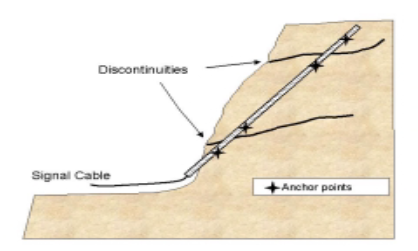
· An extensometer consists of tensioned rods anchored at different points in a borehole. Changes in the distance between the anchor and the rod head provide the displacement information for the rock mass.
2) Piezometer:
· Piezometers are used to measure pore pressures and are valuable tools for evaluating the effectiveness of mine dewatering programs and the effects of seasonal variations.
· Excessive pore pressures, especially water infiltration at geologic boundaries, are responsible for many slope failures.
· Data on water pressure is essential for maintaining safe slopes since water behind a rock slope will decrease the resisting forces and will increase the driving forces on potentially unstable rock masses.
· Highwalls should be visually examined for new seeps or changes in flow rates as these are sometimes precursors to highwall failure.
· Additionally, pit slopes should be thoroughly examined for new zones of movement after heavy rains or snowmelts.
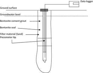
Working of piezometer:
· Piezometer tip: The tip has an electronic device to measure the pore pressure.
· Filter sand: Filter sand allows the water to flow to the piezometer tip.
· Bentonite seal: The bentonite seal stops the water migrating from top aquifers.
· Bentonite cement grout: The bentonite cement grout serves the same purpose as the bentonite seal. This is a much cheaper product
3)
Inclinometers:
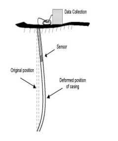
· An inclinometer consists of a casing that is placed in the ground through the area of expected movements.
· The end of the casing is assumed to be fixed so that the lateral profile of displacement can be calculated.
· The casing has grooves cut on the sides that serve as tracks for the sensing unit.
· The deflection of the casing, and hence the surrounding rock mass, are measured by determining the inclination of the sensing unit at various points along the length of the installations.
· The information collected from the inclinometers is important to slope stability studies for the following reasons:
•To locate shear zone(s)
•To determine whether the shear along the zone(s) is planar or rotational
•To measure the movement along the shear zone(s) and determine whether the movement is constant, accelerating, or decelerating
4) Time Domain Reflectometry (TDR):
· Time Domain Reflectometry is a technique in which electronic pulses are sent down a length of a coaxial cable.
· When deformation or a break in the cable is encountered, a signal is reflected giving information on the subsurface rock mass deformation.
· While inclinometers are more common for monitoring subsurface displacements, TDR cables are gaining popularity and have several advantages over traditional inclinometers
• Lower cost of installation
• Deeper hole depths possible.
• Rapid and remote monitoring possible
• Immediate deformation determinations
•Complex installations possible.
SURFACE MEASUREMENTS
1) Tension Crack Mapping
· The formation of cracks at the top of a slope is an obvious sign of instability.
· Measuring and monitoring the changes in crack width and direction of crack propagation is required to establish the extent of the unstable area.
· Existing cracks should be painted or flagged so that new cracks can be easily identified on subsequent inspections.
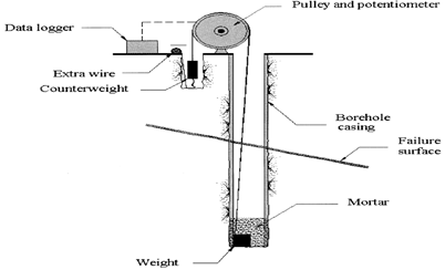
· A common method for monitoring movement across tension cracks is with a portable wire-line extensometer as shown in figure.
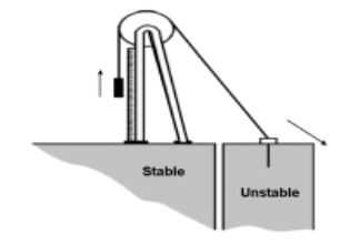
Portable wire-line extensometer for monitoring a tension crack.
· The most common setup is comprised of a wire anchored in the unstable portion of the ground, with the monitor and pulley station located on a stable portion of the ground behind the last tension crack.
· The wire runs over the top of a pulley and is tensioned by a weight suspended from the other end.
· As the unstable portion of the ground moves away from the pulley stand, the weight will move and the displacements can be recorded either electronically or manually.
· Long lengths of wire can lead to errors due to sag or to thermal expansion, so readjustments and corrections are often necessary.
· The length of the extensometer wire should be limited to approximately 60 m (197 ft) to keep the errors due to line sag at a minimum.
2) Survey Network:
· A survey network consists of target prisms placed on and around areas of anticipated instability on the slopes, and on one or more non-moving control points for survey stations.
· The angles and distances from the survey station to the prisms are measured on a regular basis to establish a history of movement on the slope.
· It is extremely important to place the permanent control points for the survey stations on stable ground.
· The surveys can be done manually by a survey crew or can be automated.
HIGHWALL MONITORING USING RADAR SYSTEMS
1) Interferometric Synthetic Aperture Radar (IFSAR)
· Synthetic aperture radar (SAR) is a type of ground-mapping radar originally designed to be used from aircraft and satellites.
· SAR can be used to generate high quality digital elevation maps (DEM’s) and to detect disturbances of the earth’s surface.
· Interferometric Synthetic Aperture Radar (IFSAR) is a variation of SAR that uses differences in time-lapsed SAR images to generate maps of displacements.
· This technique has been successfully applied to produce displacement maps of ground movement caused by earthquakes, volcanic activity, and mine subsidence.
· IFSAR can also be used to monitor displacement of unstable slopes or landslides.
· IFSAR’s have many advantages over current types of monitoring systems.
· Able to work in nearly all weather, an IFSAR can acquire imagery through fog, mist, rain, haze, or cloud cover, and can operate day or night.
· An IFSAR can sample a
large area for ground displacements, which gives them a tremendous advantage
over survey networks, extensometers, and other instruments which sample
movement on a discrete set of points.
CLICK ME TO DOWNLOAD THE NOTES ON SLOPE MONITORING SYSTEM


No comments added yet!