NATIONAL GRID
WHAT IS THE NATIONAL GRID
The national grid is a common reference point throughout the country with reference to the single prime meridian coincident with the point of origin at Greenwich.
The grid reference system of the map is the defined location in the map in the geographical coordinate system. The surface of the earth has nature in curved it is impossible to show on flat paper with the parallel meridian. It is shown on the map to a plane grid system coordinate system is referred to as a map projection.
The national grid reference system is different from the geographical coordinate system. It is referred to in the cartesian coordinate system. The grid reference system has required a datum for measuring the distance in a coordinate system.
The datum is defined as the reference datum is used to describe the location of unknown points on the earth.
The no of various datum is used for measurement. In India there are generally two datum is used for mapping WGS1984 and Everest 1956 or India Nepal datum. Now a day survey of India used Datum WGS 1984 and projection UTM.
`Projection is used to defined as the curved surface of the earth or part to represent a flat surface
There are three types of projection used in the mapping.
- Conic projection
- Cylindrical projection
- Planar projection
India used generally two types of projection Lambert conformal conic projection and Universal Transverse Mercator(UTM).
.Everest 1956 or India Nepal datum.
The Indian National Grid system uses theEverest Spheroid as a reference surface. It was originally defined in 1830 by Colonel George Everest (Surveyor-General Of India from 1830 to 1843) and updated in 1956. Kalianpur (Madhya Pradesh ) was chosen as the initial point of origin.
It is a local datum. The Centre of this reference surface is estimated to about 1 kilometer off from the center of mass of the Earth.
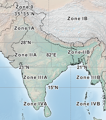
India Nepal datum the area of covered in ninzones.

Grid reference zone


No comments added yet!